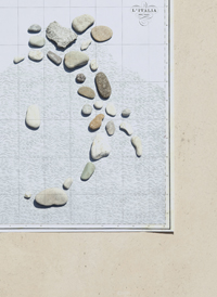
First section. Rocks and water
is the purpose of geography to make war?
Representation of human beings
an exhibition of maps and art
The first theme treated in this exhibition is the concept of “natural border”, namely the use of certain elements of geographical landscape (water courses, mountain chains) as lines that a distinction, a division runs along.
And this is not a simple enunciation made by a physical geography manual, being, one hundred years ago, one of the fundamental concepts as to why the Kingdom of Italy entered into war against the Austrian-Hungarian Empire. The Proclamation of the King signed by Victor Emmanuel III and published in «Corriere della Sera» on 27 May 1915 was addressed directly to the soldiers: «To you will belong the glory of planting the flag of Italy upon the sacred con-
fines which nature placed as the boundaries of our country».
For centuries the Alpine barrier was considered as the symbol of border and defence of the Italian territory and was referred to in poetic literature since the famous lines of Dante and Petrarch. For a long time it was believed that God’s, or nature’s, will could have effectively drawn out “natural” regions intended for given civilisations, populations, countries. However “natural borders” do not exist. Historian Gaetano Salvemini and geographer Carlo Maranelli clearly explain this in 1918: «there are no natural political borders, because all political borders are artificial, meaning that they are created by the conscience and will of man».
With a series of geographic maps, this section sheds light on the misunderstanding through which geographical theories were used to express biased points of view, pervaded by the predominant cultural trend, the “spirit of the times”. Maps that convey the idea of Italian unity well before it was a political reality and able to graphically express profound historical-cultural values and abstract concepts such as nation.
